
List of mountain ranges of Colorado

All the major mountain ranges in the U.S. State of Colorado are considered subranges of the Southern Rocky Mountains.
As given in the table, topographic elevation is the vertical distance above the reference geoid, a mathematical model of the Earth's sea level as an equipotential gravitational surface. The topographic prominence of a summit is the elevation difference between that summit and the highest or key col to a higher summit. The topographic isolation of a summit is the minimum great-circle distance to a point of equal elevation.
All elevations in this article include an elevation adjustment from the National Geodetic Vertical Datum of 1929 (NGVD 29) to the North American Vertical Datum of 1988 (NAVD 88). For further information, please see this United States National Geodetic Survey note. If an elevation or prominence is calculated as a range of values, the arithmetic mean is shown.
Mountain ranges[edit]
Gallery[edit]
-

-
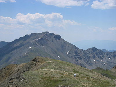 Mount Harvard is the highest of the Collegiate Peaks and the third-highest peak of the Rocky Mountains.
 -
 Blanca Peak is the highest peak of the Sangre de Cristo Mountains and the fifth-highest peak of the Rocky Mountains.
 -
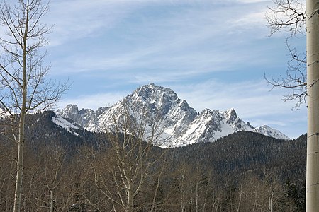
 Uncompahgre Peak is the highest peak of the San Juan Mountains and the sixth-highest peak of the Rocky Mountains.
 -
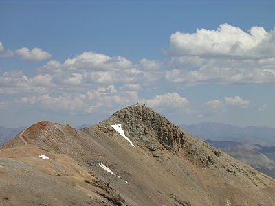
 Crestone Peak is the highest peak of the Crestones and the seventh-highest peak of the Rocky Mountains.
 -
 Mount Lincoln is the highest peak of the Mosquito Range and the eighth-highest peak of the Rocky Mountains.
 -
 Castle Peak is the highest peak of the Elk Mountains and the ninth-highest peak of the Rocky Mountains.
 -
 Grays Peak is the highest peak of the Front Range and the tenth-highest peak of the Rocky Mountains.
 -

-
-
-
-
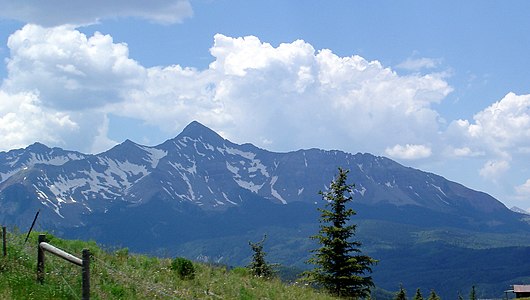
 Pikes Peak is the highest peak of the Southern Front Range. The mountain was the inspiration for "America the Beautiful".
 -
 Mount of the Holy Cross is the highest peak of the Northern Sawatch Range. This photograph was taken by William Henry Jackson in 1874.
 -

-


_-_2006-07-16.jpg)


See also[edit]
- Southern Rocky Mountains#Mountain ranges
- Bibliography of Colorado
- Geography of Colorado
- History of Colorado
- Index of Colorado-related articles
- List of Colorado-related lists
- Outline of Colorado
Notes[edit]
- ^ The summit of Mount Elbert is the highest point of the Rocky Mountains, the State of Colorado, and Lake County.
- ^ The elevation of Mount Elbert includes an adjustment of +1.995 m (6.55 ft) from NGVD 29 to NAVD 88.
- ^ Mount Massive is the second highest peak of the Rocky Mountains..
- ^ The elevation of Mount Massive includes an adjustment of +2.087 m (6.85 ft) from NGVD 29 to NAVD 88.
- ^ The summit of Mount Harvard is the highest point of the Collegiate Peaks and Chaffee County, Colorado.
- ^ The elevation of Mount Harvard includes an adjustment of +2.084 m (6.84 ft) from NGVD 29 to NAVD 88.
- ^ The summit of Bill Williams Peak is the highest point of the Williams Mountains.
- ^ The elevation of Bill Williams Peak includes an adjustment of +2.044 m (6.71 ft) from NGVD 29 to NAVD 88.
- ^ The summit of Mount Antero is the highest point of the southern Sawatch Range.
- ^ The elevation of Mount Antero includes an adjustment of +2.071 m (6.79 ft) from NGVD 29 to NAVD 88.
- ^ The summit of Mount Ouray is the highest point of the far southern Sawatch Range.
- ^ The elevation of Mount Ouray includes an adjustment of +1.871 m (6.14 ft) from NGVD 29 to NAVD 88.
- ^ The summit of Mount of the Holy Cross is the highest point of the northern Sawatch Range and Eagle County, Colorado.
- ^ The summit elevation of Mount of the Holy Cross includes a vertical offset of +0.61 m (2 ft) from the station benchmark.
- ^ The elevation of Mount of the Holy Cross includes an adjustment of +1.926 m (6.32 ft) from NGVD 29 to NAVD 88.
- ^ The summit of Blanca Peak is the highest point of the Sierra Blanca Massif, the Sangre de Cristo Mountains, Alamosa County and Costilla County, Colorado.
- ^ The elevation of Blanca Peak includes an adjustment of +1.755 m (5.76 ft) from NGVD 29 to NAVD 88.
- ^ The summit of Crestone Peak is the highest point of the northern Sangre de Cristo Mountains and Saguache County, Colorado.
- ^ The elevation of Crestone Peak includes an adjustment of +1.76 m (5.77 ft) from NGVD 29 to NAVD 88.
- ^ The elevation of Rito Alto Peak includes an adjustment of +1.808 m (5.93 ft) from NGVD 29 to NAVD 88.
- ^ The summit of Culebra Peak is the highest point of the Culebra Range.
- ^ The elevation of Culebra Peak includes an adjustment of +1.74 m (5.71 ft) from NGVD 29 to NAVD 88.
- ^ The summit of West Spanish Peak is the highest point of Las Animas County, Colorado.
- ^ West Spanish Peak is the easternmost 13,000-foot (4,000 m) summit of the United States..
- ^ The elevation of West Spanish Peak includes an adjustment of +1.468 m (4.82 ft) from NGVD 29 to NAVD 88.
- ^ The summit of Greenhorn Mountain is the highest point of the Wet Mountains and Pueblo County, Colorado.
- ^ The elevation of Greenhorn Mountain includes an adjustment of +1.401 m (4.6 ft) from NGVD 29 to NAVD 88.
- ^ The summit of Uncompahgre Peak is the highest point of the San Juan Mountains and Hinsdale County, Colorado.
- ^ The elevation of Uncompahgre Peak includes an adjustment of +1.967 m (6.45 ft) from NGVD 29 to NAVD 88.
- ^ The summit of Mount Wilson is the highest point of the San Miguel Mountains and Dolores County, Colorado.
- ^ The elevation of Mount Wilson includes an adjustment of +1.899 m (6.23 ft) from NGVD 29 to NAVD 88.
- ^ The summit of Mount Sneffels is the highest point of the Sneffels Range and Ouray County, Colorado.
- ^ The elevation of Mount Sneffels includes an adjustment of +1.879 m (6.16 ft) from NGVD 29 to NAVD 88.
- ^ The summit of Windom Peak is the highest point of the Needle Mountains and La Plata County, Colorado.
- ^ Mount Eolus may be higher than Windom Peak..
- ^ The elevation of Windom Peak includes an adjustment of +1.785 m (5.86 ft) from NGVD 29 to NAVD 88.
- ^ The summit of Vestal Peak is the highest point of the Grenadier Range.
- ^ The elevation of Vestal Peak includes an adjustment of +1.781 m (5.84 ft) from NGVD 29 to NAVD 88.
- ^ The summit of Twilight Peak is the highest point of the West Needle Mountains.
- ^ The elevation of Twilight Peak includes an adjustment of +1.537 m (5.04 ft) from NGVD 29 to NAVD 88.
- ^ The summit of Phoenix Peak is the highest point of the La Garita Mountains.
- ^ The elevation of Phoenix Peak includes an adjustment of +2 m (6.56 ft) from NGVD 29 to NAVD 88.
- ^ The summit of Long Branch Baldy is the highest point of the Cochetopa Hills.
- ^ The elevation of Long Branch Baldy includes an adjustment of +1.86 m (6.1 ft) from NGVD 29 to NAVD 88.
- ^ The summit of Half Peak is the highest point of the east central San Juan Mountains.
- ^ The elevation of Half Peak includes an adjustment of +1.998 m (6.56 ft) from NGVD 29 to NAVD 88.
- ^ The summit of Summit Peak is the highest point of the southern San Juan Mountains and Archuleta County, Colorado.
- ^ The summit elevation of Summit Peak includes a vertical offset of -0.15 m (-0.5 ft) from the station benchmark.
- ^ The elevation of Summit Peak includes an adjustment of +1.877 m (6.16 ft) from NGVD 29 to NAVD 88.
- ^ The summit of Hesperus Mountain is the highest point of the La Plata Mountains and Montezuma County, Colorado.
- ^ The elevation of Hesperus Mountain includes an adjustment of +1.65 m (5.41 ft) from NGVD 29 to NAVD 88.
- ^ The summit of Mount Lincoln is the highest point of the Mosquito Range and Park County, Colorado.
- ^ The elevation of Mount Lincoln includes an adjustment of +2.098 m (6.88 ft) from NGVD 29 to NAVD 88.
- ^ The summit of Quandary Peak is the highest point of the Tenmile Range.
- ^ The elevation of Quandary Peak includes an adjustment of +2.071 m (6.79 ft) from NGVD 29 to NAVD 88.
- ^ The summit of Grays Peak is the highest point of the Front Range, the Continental Divide of North America, Clear Creek County and Summit County, Colorado.
- ^ The elevation of Grays Peak includes an adjustment of +1.881 m (6.17 ft) from NGVD 29 to NAVD 88.
- ^ The summit elevation of Mount Blue Sky includes a vertical offset of +1.8 m (5.9 ft) from the station benchmark.
- ^ The elevation of Mount Blue Sky includes an adjustment of +1.827 m (5.99 ft) from NGVD 29 to NAVD 88.
- ^ The summit of Longs Peak is the highest point of the northern Front Range, Rocky Mountain National Park, and Boulder County, Colorado.
- ^ The elevation of Longs Peak includes an adjustment of +1.652 m (5.42 ft) from NGVD 29 to NAVD 88.
- ^ The summit of Hagues Peak is the highest point of the Mummy Range and Larimer County, Colorado.
- ^ The elevation of Hagues Peak includes an adjustment of +1.719 m (5.64 ft) from NGVD 29 to NAVD 88.
- ^ The summit of North Arapaho Peak is the highest point of the Indian Peaks.
- ^ The elevation of North Arapaho Peak includes an adjustment of +1.763 m (5.78 ft) from NGVD 29 to NAVD 88.
- ^ The summit of Mount Richthofen is the highest point of the Never Summer Mountains.
- ^ The elevation of Mount Richthofen includes an adjustment of +1.658 m (5.44 ft) from NGVD 29 to NAVD 88.
- ^ The summit of Pikes Peak is the highest point of the southern Front Range and El Paso County, Colorado.
- ^ Pikes Peak is the easternmost 14,000-foot (4,300 m) summit of the United States. Pikes Peak was the inspiration for the lyrics of America the Beautiful..
- ^ The elevation of Pikes Peak includes an adjustment of +1.678 m (5.51 ft) from NGVD 29 to NAVD 88.
- ^ The summit of Ptarmigan Peak is the highest point of the South Williams Fork Mountains.
- ^ The elevation of Ptarmigan Peak includes an adjustment of +1.789 m (5.87 ft) from NGVD 29 to NAVD 88.
- ^ The summit of Knobby Crest is the highest point of the Kenosha Mountains.
- ^ The elevation of Knobby Crest includes an adjustment of +1.595 m (5.23 ft) from NGVD 29 to NAVD 88.
- ^ The summit of Bison Peak is the highest point of the Tarryall Mountains.
- ^ The elevation of Bison Peak includes an adjustment of +1.623 m (5.32 ft) from NGVD 29 to NAVD 88.
- ^ The summit of Waugh Mountain is the highest point of the South Park Hills.
- ^ The elevation of Waugh Mountain includes an adjustment of +1.702 m (5.58 ft) from NGVD 29 to NAVD 88.
- ^ The summit of Devils Head is the highest point of the Rampart Range.
- ^ The elevation of Devils Head includes an adjustment of +1.239 m (4.06 ft) from NGVD 29 to NAVD 88.
- ^ The summit of Castle Peak is the highest point of the Elk Mountains, Gunnison County and Pitkin County, Colorado.
- ^ The elevation of Castle Peak includes an adjustment of +2.165 m (7.1 ft) from NGVD 29 to NAVD 88.
- ^ The summit of Mount Owen is the highest point of the Ruby Range.
- ^ The elevation of Mount Owen includes an adjustment of +1.99 m (6.53 ft) from NGVD 29 to NAVD 88.
- ^ The summit of West Elk Peak is the highest point of the West Elk Mountains.
- ^ The elevation of West Elk Peak includes an adjustment of +2.105 m (6.91 ft) from NGVD 29 to NAVD 88.
- ^ The summit of Mount Powell is the highest point of the Gore Range.
- ^ The elevation of Mount Powell includes an adjustment of +1.771 m (5.81 ft) from NGVD 29 to NAVD 88.
- ^ The summit of Clark Peak is the highest point of the Medicine Bow Mountains and Jackson County, Colorado.
- ^ The summit elevation of Clark Peak includes a vertical offset of +1.83 m (6 ft) from the station benchmark.
- ^ The elevation of Clark Peak includes an adjustment of +1.628 m (5.34 ft) from NGVD 29 to NAVD 88.
- ^ The summit of Flat Top Mountain is the highest point of the Flat Tops and Garfield County, Colorado.
- ^ The elevation of Flat Top Mountain includes an adjustment of +1.698 m (5.57 ft) from NGVD 29 to NAVD 88.
- ^ The summit of Parkview Mountain is the highest point of the Rabbit Ears Range.
- ^ The elevation of Parkview Mountain includes an adjustment of +1.589 m (5.21 ft) from NGVD 29 to NAVD 88.
- ^ The summit of Mount Zirkel is the highest point of the Park Range and Routt County, Colorado.
- ^ The elevation of Mount Zirkel includes an adjustment of +1.632 m (5.35 ft) from NGVD 29 to NAVD 88.
- ^ The summit of Sand Mountain North is the highest point of the Elkhead Mountains.
- ^ The elevation of Sand Mountain North includes an adjustment of +1.502 m (4.93 ft) from NGVD 29 to NAVD 88.
- ^ The summit of Blair Mountain is the highest point of the White River Plateau.
- ^ The elevation of Blair Mountain includes an adjustment of +1.565 m (5.13 ft) from NGVD 29 to NAVD 88.
- ^ The summit of Crater Peak is the highest point of Grand Mesa.
- ^ The elevation of Crater Peak includes an adjustment of +1.75 m (5.74 ft) from NGVD 29 to NAVD 88.
- ^ The summit of South Bald Mountain is the highest point of the Laramie Mountains.
- ^ The summit elevation of South Bald Mountain includes a vertical offset of +0.61 m (2 ft) from the station benchmark.
- ^ The elevation of South Bald Mountain includes an adjustment of +1.424 m (4.67 ft) from NGVD 29 to NAVD 88.
- ^ The summit of Horsefly Peak is the highest point of the Uncompahgre Plateau.
- ^ The elevation of Horsefly Peak includes an adjustment of +1.581 m (5.19 ft) from NGVD 29 to NAVD 88.
- ^ The summit of Ute Peak is the highest point of Ute Mountain.
- ^ The elevation of Ute Peak includes an adjustment of +1.139 m (3.74 ft) from NGVD 29 to NAVD 88.
References[edit]
- ^ "Sawatch Range". Mountain Ranges of the World. peakbagger.com. Retrieved September 26, 2014.
- ^ The place name "Sawatch" is pronounced /səˈwætʃ/. This name derives from the Ute language noun "sawup" /səˈwʌp/, meaning "sand dunes". The Spanish language version of this name is usually spelled "Saguache", while the English language version is usually spelled "Sawatch".
- ^ "Elbert Massif". Mountain Ranges of the World. peakbagger.com. Retrieved March 9, 2012.
- ^ "Mount Elbert". Datasheet for NGS Station KL0637. U.S. National Geodetic Survey. Retrieved September 23, 2014.
- ^ "Mount Elbert". Peakbagger.com. Retrieved September 23, 2014.
- ^ "Massive Massif". Mountain Ranges of the World. peakbagger.com. Retrieved March 9, 2012.
- ^ "Mount Massive". Datasheet for NGS Station KL0640. U.S. National Geodetic Survey. Retrieved September 24, 2014.
- ^ "Mount Massive". Peakbagger.com. Retrieved September 24, 2014.
- ^ "Collegiate Peaks". Mountain Ranges of the World. peakbagger.com. Retrieved March 9, 2012.
- ^ "Mount Harvard". Datasheet for NGS Station JL0879. U.S. National Geodetic Survey. Retrieved September 23, 2014.
- ^ "Mount Harvard". Peakbagger.com. Retrieved September 23, 2014.
- ^ "Williams Mountains". Mountain Ranges of the World. peakbagger.com. Retrieved March 9, 2012.
- ^ "Bill Williams Peak". Peakbagger.com. Retrieved September 24, 2014.
- ^ "Southern Sawatch Range". Mountain Ranges of the World. peakbagger.com. Retrieved March 9, 2012.
- ^ "Mount Antero". Datasheet for NGS Station JL0883. U.S. National Geodetic Survey. Retrieved September 23, 2014.
- ^ "Mount Antero". Peakbagger.com. Retrieved September 23, 2014.
- ^ "Far Southern Sawatch Range". Mountain Ranges of the World. peakbagger.com. Retrieved March 9, 2012.
- ^ "Mount Ouray". Datasheet for NGS Station JL0672. U.S. National Geodetic Survey. Retrieved September 23, 2014.
- ^ "Mount Ouray". Peakbagger.com. Retrieved September 23, 2014.
- ^ "Northern Sawatch Range". Mountain Ranges of the World. peakbagger.com. Retrieved March 9, 2012.
- ^ "MT HOLY CROSS ET". Datasheet for NGS Station KL0649. U.S. National Geodetic Survey. Retrieved October 7, 2014.
- ^ "Mount of the Holy Cross". Peakbagger.com. Retrieved October 7, 2014.
- ^ "Sangre de Cristo Mountains". Mountain Ranges of the World. peakbagger.com. Retrieved March 9, 2012.
- ^ "Sierra Blanca Massif". Mountain Ranges of the World. peakbagger.com. Retrieved March 9, 2012.
- ^ "Blanca Peak". Peakbagger.com. Retrieved September 23, 2014.
- ^ "Northern Sangre de Cristo Range". Mountain Ranges of the World. peakbagger.com. Retrieved March 9, 2012.
- ^ "Crestones". Mountain Ranges of the World. peakbagger.com. Retrieved March 9, 2012.
- ^ "Crestone Peak". Peakbagger.com. Retrieved September 23, 2014.
- ^ "Rito Alto Peak". Datasheet for NGS Station JK1300. U.S. National Geodetic Survey. Retrieved September 29, 2014.
- ^ "Rito Alto Peak". Peakbagger.com. Retrieved September 29, 2014.
- ^ "Culebra Range". Mountain Ranges of the World. peakbagger.com. Retrieved March 9, 2012.
- ^ "Culebra Peak". Peakbagger.com. Retrieved September 23, 2014.
- ^ "Spanish Peaks". Mountain Ranges of the World. peakbagger.com. Retrieved March 9, 2012.
- ^ "West Spanish Peak". Peakbagger.com. Retrieved September 24, 2014.
- ^ "Wet Mountains". Mountain Ranges of the World. peakbagger.com. Retrieved March 9, 2012.
- ^ "Greenhorn Mountain". Datasheet for NGS Station HK0512. U.S. National Geodetic Survey. Retrieved September 23, 2014.
- ^ "Greenhorn Mountain". Peakbagger.com. Retrieved September 23, 2014.
- ^ "San Juan Mountains". Mountain Ranges of the World. peakbagger.com. Retrieved March 9, 2012.
- ^ "North Central San Juan Mountains". Mountain Ranges of the World. peakbagger.com. Retrieved March 9, 2012.
- ^ "Uncompahgre Peak". Datasheet for NGS Station JL0798. U.S. National Geodetic Survey. Retrieved September 23, 2014.
- ^ "Uncompahgre Peak". Peakbagger.com. Retrieved September 23, 2014.
- ^ "San Miguel Mountains". Mountain Ranges of the World. peakbagger.com. Retrieved March 9, 2012.
- ^ "Mount Wilson". Peakbagger.com. Retrieved September 23, 2014.
- ^ "Sneffels Range". Mountain Ranges of the World. peakbagger.com. Retrieved March 9, 2012.
- ^ "Mount Sneffels". Datasheet for NGS Station JL0826. U.S. National Geodetic Survey. Retrieved September 23, 2014.
- ^ "Mount Sneffels". Peakbagger.com. Retrieved September 23, 2014.
- ^ "Needle Mountains". Mountain Ranges of the World. peakbagger.com. Retrieved March 9, 2012.
- ^ "Windom Peak". Peakbagger.com. Retrieved September 25, 2014.
- ^ "Grenadier Range". Mountain Ranges of the World. peakbagger.com. Retrieved March 9, 2012.
- ^ "Vestal Peak". Peakbagger.com. Retrieved September 26, 2014.
- ^ "West Needle Mountains". Mountain Ranges of the World. peakbagger.com. Retrieved March 9, 2012.
- ^ "Twilight Peak". Peakbagger.com. Retrieved September 24, 2014.
- ^ "La Garita Mountains". Geographic Names Information System. United States Geological Survey, United States Department of the Interior. Retrieved 19 March 2024.
- ^ "Phoenix Peak". Peakbagger.com. Retrieved September 23, 2014.
- ^ "Cochetopa Hills". Geographic Names Information System. United States Geological Survey, United States Department of the Interior. Retrieved 19 March 2024.
- ^ "Long Branch Baldy". Datasheet for NGS Station JL0682. U.S. National Geodetic Survey. Retrieved September 26, 2014.
- ^ "Long Branch Baldy". Peakbagger.com. Retrieved September 26, 2014.
- ^ "East Central San Juan Mountains". Mountain Ranges of the World. peakbagger.com. Retrieved March 9, 2012.
- ^ "Half Peak". Peakbagger.com. Retrieved September 26, 2014.
- ^ "Southern San Juan Mountains". Mountain Ranges of the World. peakbagger.com. Retrieved March 9, 2012.
- ^ "SUMMIT". Datasheet for NGS Station HL0503. U.S. National Geodetic Survey. Retrieved October 7, 2014.
- ^ "Summit Peak". Peakbagger.com. Retrieved October 7, 2014.
- ^ "La Plata Mountains". Mountain Ranges of the World. peakbagger.com. Retrieved March 9, 2012.
- ^ "Hesperus Mountain". Peakbagger.com. Retrieved September 23, 2014.
- ^ "Mosquito Range". Mountain Ranges of the World. peakbagger.com.
- ^ "Mount Lincoln". Datasheet for NGS Station KL0627. U.S. National Geodetic Survey. Retrieved September 23, 2014.
- ^ "Mount Lincoln". Peakbagger.com. Retrieved September 23, 2014.
- ^ "Tenmile Range". Mountain Ranges of the World. peakbagger.com. Retrieved March 9, 2012.
- ^ "Quandary Peak". Datasheet for NGS Station KL0622. U.S. National Geodetic Survey. Retrieved September 25, 2014.
- ^ "Quandary Peak". Peakbagger.com. Retrieved September 25, 2014.
- ^ "Front Range". Mountain Ranges of the World. peakbagger.com. Retrieved March 9, 2012.
- ^ "Central Front Range". Mountain Ranges of the World. peakbagger.com. Retrieved March 9, 2012.
- ^ "Grays Peak". Datasheet for NGS Station KK2036. U.S. National Geodetic Survey. Retrieved September 24, 2014.
- ^ "Grays Peak". Peakbagger.com. Retrieved September 24, 2014.
- ^ "EVANS". Datasheet for NGS Station KK2030. U.S. National Geodetic Survey. Retrieved October 7, 2014.
- ^ "Mount Blue Sky". Peakbagger.com. Retrieved October 7, 2014.
- ^ "Northern Front Range". Mountain Ranges of the World. peakbagger.com. Retrieved March 9, 2012.
- ^ "Twin Peaks Massif". Mountain Ranges of the World. peakbagger.com. Retrieved March 9, 2012.
- ^ "Longs Peak". Datasheet for NGS Station LL1346. U.S. National Geodetic Survey. Retrieved September 23, 2014.
- ^ "Longs Peak". Peakbagger.com. Retrieved September 23, 2014.
- ^ "Mummy Range". Mountain Ranges of the World. peakbagger.com. Retrieved March 9, 2012.
- ^ "Hagues Peak". Datasheet for NGS Station LL1350. U.S. National Geodetic Survey. Retrieved September 23, 2014.
- ^ "Hagues Peak". Peakbagger.com. Retrieved September 23, 2014.
- ^ "Indian Peaks". Mountain Ranges of the World. peakbagger.com. Retrieved March 9, 2012.
- ^ "North Arapaho Peak". Datasheet for NGS Station LL1357. U.S. National Geodetic Survey. Retrieved September 23, 2014.
- ^ "North Arapaho Peak". Peakbagger.com. Retrieved September 23, 2014.
- ^ "Never Summer Mountains". Mountain Ranges of the World. peakbagger.com. Retrieved March 9, 2012.
- ^ "Mount Richthofen". Peakbagger.com. Retrieved September 24, 2014.
- ^ "Pikes Peak". Datasheet for NGS Station JK1242. U.S. National Geodetic Survey. Retrieved September 23, 2014.
- ^ "Pikes Peak". Peakbagger.com. Retrieved September 23, 2014.
- ^ "South Williams Fork Mountains". Mountain Ranges of the World. peakbagger.com. Retrieved March 9, 2012.
- ^ "Ptarmigan Peak". Peakbagger.com. Retrieved September 26, 2014.
- ^ "Kenosha Mountains". Mountain Ranges of the World. peakbagger.com. Retrieved March 9, 2012.
- ^ "Knobby Crest". Peakbagger.com. Retrieved September 24, 2014.
- ^ "Tarryall Mountains". Mountain Ranges of the World. peakbagger.com. Retrieved March 9, 2012.
- ^ "Bison Peak". Datasheet for NGS Station KK1966. U.S. National Geodetic Survey. Retrieved September 24, 2014.
- ^ "Bison Peak". Peakbagger.com. Retrieved September 24, 2014.
- ^ "South Park Hills". Mountain Ranges of the World. peakbagger.com. Retrieved March 9, 2012.
- ^ "Waugh Mountain". Peakbagger.com. Retrieved September 24, 2014.
- ^ "Devils Head". Datasheet for NGS Station KK1932. U.S. National Geodetic Survey. Retrieved March 17, 2024.
- ^ "Devils Head". Peakbagger.com. Retrieved March 17, 2024.
- ^ "Elk Mountains". Mountain Ranges of the World. peakbagger.com. Retrieved March 9, 2012.
- ^ "Castle Peak". Datasheet for NGS Station KL0659. U.S. National Geodetic Survey. Retrieved September 23, 2014.
- ^ "Castle Peak". Peakbagger.com. Retrieved September 23, 2014.
- ^ "Mount Owen". Datasheet for NGS Station JL0737. U.S. National Geodetic Survey. Retrieved September 26, 2014.
- ^ "Mount Owen". Peakbagger.com. Retrieved September 26, 2014.
- ^ "West Elk Mountains". Mountain Ranges of the World. peakbagger.com. Retrieved March 9, 2012.
- ^ "West Elk Peak". Datasheet for NGS Station JL0755. U.S. National Geodetic Survey. Retrieved September 24, 2014.
- ^ "West Elk Peak". Peakbagger.com. Retrieved September 24, 2014.
- ^ "Gore Range". Mountain Ranges of the World. peakbagger.com. Retrieved March 9, 2012.
- ^ "Mount Powell". Peakbagger.com. Retrieved September 24, 2014.
- ^ "Medicine Bow Mountains". Mountain Ranges of the World. peakbagger.com. Retrieved March 9, 2012.
- ^ "CLARK". Datasheet for NGS Station LL1388. U.S. National Geodetic Survey. Retrieved October 7, 2014.
- ^ "Clark Peak". Peakbagger.com. Retrieved October 7, 2014.
- ^ "Flat Tops". Mountain Ranges of the World. peakbagger.com. Retrieved September 26, 2014.
- ^ "Flat Top Mountain". Datasheet for NGS Station LM0694. U.S. National Geodetic Survey. Retrieved September 24, 2014.
- ^ "Flat Top Mountain". Peakbagger.com. Retrieved September 24, 2014.
- ^ "Rabbit Ears Range". Mountain Ranges of the World. peakbagger.com. Retrieved March 9, 2012.
- ^ "Parkview Mountain". Datasheet for NGS Station LM0574. U.S. National Geodetic Survey. Retrieved September 24, 2014.
- ^ "Parkview Mountain". Peakbagger.com. Retrieved September 24, 2014.
- ^ "Park Range". Mountain Ranges of the World. peakbagger.com. Retrieved March 9, 2012.
- ^ "Central Park Range". Mountain Ranges of the World. peakbagger.com. Retrieved March 9, 2012.
- ^ "Mount Zirkel". Peakbagger.com. Retrieved September 23, 2014.
- ^ "Elkhead Mountains". Mountain Ranges of the World. peakbagger.com. Retrieved March 9, 2012.
- ^ "Sand Mountain North". Peakbagger.com. Retrieved September 24, 2014.
- ^ "White River Plateau". Mountain Ranges of the World. peakbagger.com. Retrieved March 9, 2012.
- ^ "Blair Mountain". Peakbagger.com. Retrieved September 24, 2014.
- ^ "Grand Mesa". Mountain Ranges of the World. peakbagger.com. Retrieved March 9, 2012.
- ^ "Crater Peak". Datasheet for NGS Station KL0706. U.S. National Geodetic Survey. Retrieved September 24, 2014.
- ^ "Crater Peak". Peakbagger.com. Retrieved September 24, 2014.
- ^ "Laramie Mountains". Mountain Ranges of the World. peakbagger.com. Retrieved March 9, 2012.
- ^ "SOUTH BALD". Datasheet for NGS Station LL1377. U.S. National Geodetic Survey. Retrieved October 7, 2014.
- ^ "South Bald Mountain". Peakbagger.com. Retrieved October 7, 2014.
- ^ "Uncompahgre Plateau". Mountain Ranges of the World. peakbagger.com. Retrieved March 9, 2012.
- ^ "Horsefly Peak". Datasheet for NGS Station JL0830. U.S. National Geodetic Survey. Retrieved September 26, 2014.
- ^ "Horsefly Peak". Peakbagger.com. Retrieved September 26, 2014.
- ^ "Ute Mountain". Mountain Ranges of the World. peakbagger.com. Retrieved March 9, 2012.
- ^ "Ute Peak". Datasheet for NGS Station HM0511. U.S. National Geodetic Survey. Retrieved September 24, 2014.
- ^ "Ute Peak". Peakbagger.com. Retrieved September 24, 2014.
External links[edit]
 Media from Commons
 News from Wikinews
 Quotations from Wikiquote
 Travel information from Wikivoyage
- State of Colorado
- United States Geological Survey
- United States National Geodetic Survey (NGS)
- Bivouac.com
- Peakbagger.com
- Peaklist.org
- Peakware.com
- Summitpost.org